
UN Adopts New World Map to Reflect Africa’s True Size
Historic resolution passes with overwhelming support, marking shift in global cartography
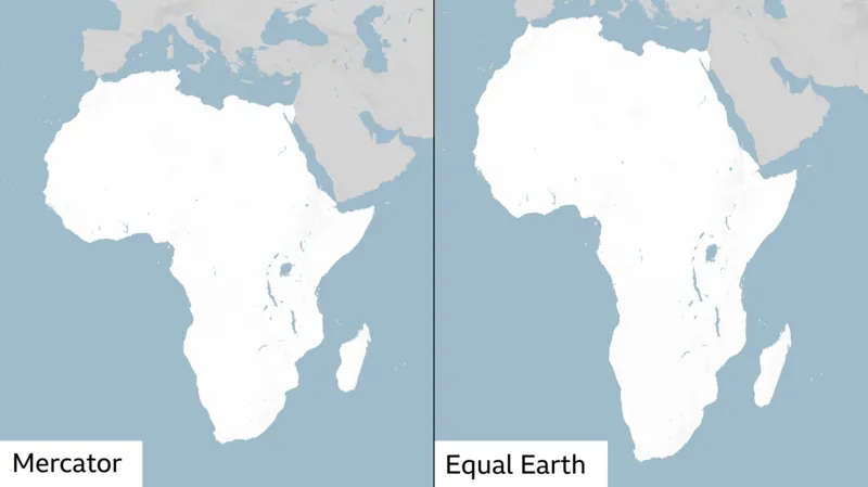
UNITED NATIONS — The United Nations General Assembly has voted to replace the traditional Mercator world map with one that more accurately depicts the true size of Africa, in a move that advocates say corrects centuries of geographic distortion.
The “Correct the Map” resolution, sponsored by Togo and backed by African Union member states, passed Friday with 164 nations in favor. France and the United Kingdom were among the supporters, while the United States cast the sole vote against. Six nations abstained.
The Map That Changed the World’s View
The Mercator projection, designed in 1569 by Flemish cartographer Gerardus Mercator to aid European navigation, has long been criticized for its distortions. While it facilitated ocean travel by preserving compass bearings, the projection dramatically inflates landmasses near the poles while shrinking those near the equator.
The result: Africa appears roughly the same size as Greenland on the map, when in reality the continent is 14 times larger, covering approximately 30.4 million square kilometers compared to Greenland’s 2.2 million.
‘A Fair World Begins with a Fair Map’
Togolese Foreign Minister Robert Dussey, whose country sponsored the resolution, told Reuters: “A fair world begins with a fair map.”
Speaking at a UN briefing, Dussey emphasized the political significance of cartography: “A map is never neutral. It shapes perceptions, influences how the place of peoples and continents in the world is understood.”
The resolution adopted the Equal Earth projection, created by cartographers in 2018, which presents a more proportionally accurate representation of continents. The African Union’s 54 member states had already endorsed this projection in February.
Critics Say Map Shapes Perceptions of Development
The #CorrectTheMap campaign group has highlighted the extent of Africa’s misrepresentation, noting: “You could fit the United States, China, India, Japan, Mexico and much of Europe into Africa and still have land to spare.”
Kenyan geographer Kioko Muendo told the BBC that the Mercator projection has implicitly downplayed the continent’s vast resources, population, and investment opportunities.
“Maps are more than just guides for travellers—they shape how regions are perceived politically and economically,” he said.
Lerato Mogoatlhe from Africa No Filter, one of the groups behind the campaign, described the issue as more than a cartographic error.
“Africa’s misrepresentation on world maps is not just a cartographic error—it’s a narrative issue,” she told the BBC. The campaign seeks to end what she called the “world’s longest misinformation and disinformation” about Africa.
French Support for Change
French Foreign Minister Jean-Noël Barrot announced that his ministry would cease using the Mercator map, though he acknowledged the resolution’s limitations.
“Changing the map obviously doesn’t change the world. But correcting a representation that distorts it is already an act of truth,” he said.
US Opposition
The United States was alone in opposing the resolution. US representative Yaryna Ferencevych criticized the vote as a distraction from more pressing international issues.
“Instead of focusing on genuine problems of international peace, prosperity, or good relations, this body is debating map projects from the 16th Century, and their role in promoting reparations and ‘cognitive justice,'” she said.
The US had previously opposed a March resolution declaring the transatlantic slave trade “the gravest crime against humanity.”
Implementation Ahead
While the UN vote is non-binding, it is expected to influence the maps used by institutions worldwide, including schools, media organizations, and international bodies.
The resolution represents a significant shift in global cartography, though some experts note that no two-dimensional map can perfectly represent a spherical Earth without some compromise.
About The Author